Navionics+ Large | Aegean Sea + Sea of Marmara Chart
Price:
€217.30
-
Code:942032


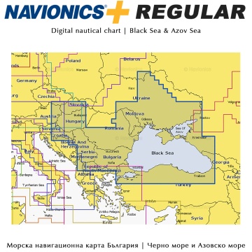
Navionics+ Large Nautical Chart | Mediterranean and Black Sea
Get detailed chart content for lakes and marine areas - plus receive a 12-month subscription to Freshest Data for updates to the Nautical Charts, new SonarCharts, Community Edits, and more! Simply plug your Navionics Plus chip into your PC/Mac and download the coverage you need from navionics.com.
- Charts: Everything on one card! Nautical Chart, SonarChart™ and Community Edits.
- Sonar Charts: Enjoy the exclusive high definition layer and upload your sonar logs to build even better local charts for your area.
- Freshest Data: Take advantage of daily updates. Download Freshest Data free for one year!
- Coverage: Navionics provides highly detailed marine and lake charts around the world. Choose from a global catalog.
- Versatile: Navionics+ is a versatile and innovative product. In stores across the world, you may find it either in the partially preloaded or in the fully downloadable versions. In both cases, the Freshest Data service allows you to download marine and lakes content and chart layers with great flexibility for one year.